The History
The post was established in April
1842 by Captain George A.H. Blake, 2nd U.S. Dragoons in Bryan County, Oklahoma.
At the time this land was part of the Chickasaw and Choctaw Nations, later
after splitting the post would be part of the the Chickasaw Nation. Initial
construction was crude and permanent construction began when two additional
companies arrived but was not completed until 1849.

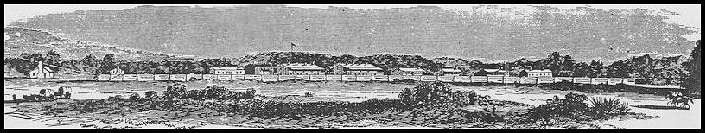
When completed, the post was an open
plan western fort with a central parade surrounded by post buildings. Large two
story barracks lined the south and west sides of the parade with a single story
stone bachelor officer's quarters (BOQ) on the east side. The Adjutant's office
and a school were placed at the north end. Officers row was built along a cobbled
road to the north that ended with the new hospital (1857). The commissary and
other support buildings were located behind the south side barracks.
|

The post was abandoned by U.S.
troops on 16 Apr 1861 at the beginning of the U.S. Civil War. Fort Washita was
occupied by Confederate troops the day after Union troops left and they
remained there throughout the war, finally abandoned it in 1865. Most of the
fort was destroyed by a fire of unknown origin on 1 Aug 1865 and was never
re-occupied by U.S. Troops.

The post property passed from the
Indian Agent, General Douglas Cooper, to the Colbert family the early 1880s. In
1962 the Oklahoma Historical Society purchased the 117 acre site with a gift
provided by the Merrick Foundation and began a restoration process. The south
barracks restoration was completed in 1972 but it was destroyed by an arson
fire in 2011.

The Cartography
|

The first recorded cartography of
Fort Washita that I have found is the 1854 map of Texas by Henry Lange. The
publisher was George Westerman in Braunschweig Germany, which brings up another
cartographic topic in its self, being that so many of the best maps and publishing
houses for the American market in the 19th century were from Europe.
The map was rather typical for the
time, as it belonged to a larger book Titled Atlas Von Nord-Amerika, but
surprisingly it is still in its original bindings with so many being cut out
and sold off piecemeal.

This map shows that the Indian
Territories were sparsely populated with only the occasional Fort, and with
many features labeled in German and English.
|

The next map that I found of
Fort Washita is from the Government Land Office (GLO) survey of 1872. This
survey is of a 36 square mile township, and is part of a larger surveying
effort of the American Territories in the west. The GLO's play a big part in
the settling of the western lands, and I will go into more detail on them in
the future.
 | |
|
This survey is a great example
of why historical cartography is so important. The community of Hapsburgh that
is shown to the west of the Fort can be found on several maps from around this
time period, but is completely absent from most of the cartographic record by
the late 1890's, which we we see in some later maps.
We can see Fort Washita rather
haphazardly placed here in Sec 23, I say this because after I georeferenced
this image in ArcMap, I found it to be almost 3/4 of a mile off its true
location, which is extreme for most GLO's surveys. Accuracy is a common problem
with most historical cartography, but if you study the techniques used by the
original surveyors this can be compensated for.
 |
| Government Land Office Survey 1899 |
This next map is also another
of the GLO surveys which was completed in 1899. You can immediately tell the
impact settlement has had on the land. Farming, roads, and fences, what the
historical geographer would call cultural features, are much more prevalent on
this map.
|

As we zoom in we can see that Fort
Washita has been moved tho the correct location. You can also tell the
Hapsburgh community is not present. The road going through the Fort is part of
the greater Military Road system, going north and to the east to Fort Smith and
Fort Gibson, and south into Texas.
Thanks a lot for visiting my blog. I
know that is a little rough right now, as I am learning on the fly. Please
check back, as there is more to come.